
Make a donation
Gopeshwar topographic map
Click on the map to display elevation.
Make a donation
Gopeshwar
Gopeshwar is located at 30°25′N 79°20′E / 30.42°N 79.33°E / 30.42; 79.33. It has an average elevation of 1,450 m (4,760 ft). Gopeshwar is 8.4 km (5.2 mi) away from Chamoli which is located on the banks of Alaknanda river and along NH 58.
Make a donation
About this map
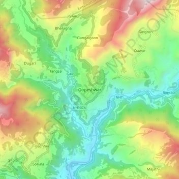
Name: Gopeshwar topographic map, elevation, terrain.
Location: Gopeshwar, Chamoli Tehsil, Chamoli, Uttarakhand, 246401, India (30.36878 79.27855 30.44878 79.35855)
Average elevation: 1,566 m
Minimum elevation: 895 m
Maximum elevation: 2,725 m
Make a donation
Other topographic maps
Click on a map to view its topography, its elevation and its terrain.
Roopkund Lake
India > Uttarakhand > Chamoli Tehsil
Roopkund (locally known as Mystery Lake or Skeleton Lake) is a high altitude glacial lake in the Uttarakhand state of India. It lies in the lap of Trishul massif. Located in the Himalayas, the area around the lake is uninhabited and is roughly at an altitude of 5,020 metres (16,470 ft), surrounded by…
Average elevation: 4,631 m