
Bonneberg topographic map
Interactive map
Click on the map to display elevation.
About this map
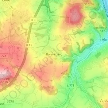
Name: Bonneberg topographic map, elevation, terrain.
Average elevation: 150 m
Minimum elevation: 44 m
Maximum elevation: 258 m
Other topographic maps
Click on a map to view its topography, its elevation and its terrain.
Uffeln
Deutschland > Nordrhein-Westfalen > Kreis Herford > Vlotho
Uffeln liegt als einziges Gebiet des Kreises Herford östlich der Weser und gehört damit geografisch nicht zum Ravensberger Land. Ein Großteil des Gebietes besteht aus dem bis zu 170 m hohen Höhenrücken Buhn. Dieser Hügel fällt an seiner südöstlichen steil ab. Sein Name ist gleichbedeutend mit…
Average elevation: 104 m