
Thank you for supporting this site ❤️
Make a donation
Make a donation
Sombrerete topographic map
Click on the map to display elevation.
Thank you for supporting this site ❤️
Make a donation
Make a donation
Sombrerete
The region is between the Sierra Madre Occidental and the central highlands of Mexico. The municipality is in a valley is surrounded on all sides by small mountain ranges such as the Sierra de Sombrerete and the Sierra de Santa María with prominent elevations such as the Cerro Grande, Cerro Reyes, Cerro Sombreretillo and Cerro Alto. The town has an altitude of about 2,300 meters above sea level with the highest elevations over 2,500.
Thank you for supporting this site ❤️
Make a donation
Make a donation
About this map
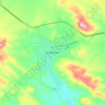
Name: Sombrerete topographic map, elevation, terrain.
Location: Sombrerete, Zacatecas, 99100, Mexico (23.59543 -103.68101 23.67543 -103.60101)
Average elevation: 2,401 m
Minimum elevation: 2,234 m
Maximum elevation: 2,701 m
Thank you for supporting this site ❤️
Make a donation
Make a donation