
Velbert topographic map
Interactive map
Click on the map to display elevation.
About this map
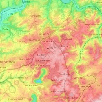
Name: Velbert topographic map, elevation, terrain.
Location: Velbert, Kreis Mettmann, Noordrijn-Westfalen, Duitsland (51.29318 7.00131 51.38142 7.16978)
Average elevation: 172 m
Minimum elevation: 21 m
Maximum elevation: 292 m
Other topographic maps
Click on a map to view its topography, its elevation and its terrain.
Mettmann
Duitsland > Noordrijn-Westfalen > Kreis Mettmann
Mettmann, Kreis Mettmann, Noordrijn-Westfalen, 40822, Duitsland
Average elevation: 149 m
Langenfeld (Rheinland)
Duitsland > Noordrijn-Westfalen > Kreis Mettmann
Langenfeld (Rheinland), Kreis Mettmann, Noordrijn-Westfalen, 40764, Duitsland
Average elevation: 55 m