
Make a donation
Arab topographic map
Click on the map to display elevation.
Make a donation
Arab
Arab is located at an elevation of 1,100 feet (340 m) on top of Brindlee Mountain, near the southwest end of the Appalachian Plateau. The city is primarily in southern Marshall County; a small portion extends south into Cullman County. U.S. Route 231 runs north-to-south through Arab, and State Route 69 runs east-to-west, through the city's business district. US 231 leads north 31 miles (50 km) to Huntsville and south 32 miles (51 km) to Oneonta, while SR 69 leads east 13 miles (21 km) to Guntersville and southwest 23 miles (37 km) to Cullman.
Make a donation
About this map
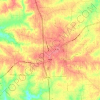
Name: Arab topographic map, elevation, terrain.
Location: Arab, Marshall County, Alabama, 35016, United States (34.28777 -86.56015 34.36571 -86.45000)
Average elevation: 314 m
Minimum elevation: 266 m
Maximum elevation: 343 m
Make a donation
Other topographic maps
Click on a map to view its topography, its elevation and its terrain.