
La Roche topographic map
Interactive map
Click on the map to display elevation.
About this map
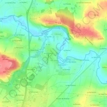
Name: La Roche topographic map, elevation, terrain.
Average elevation: 50 m
Minimum elevation: 16 m
Maximum elevation: 103 m
Other topographic maps
Click on a map to view its topography, its elevation and its terrain.
Mardin
France > Bretagne > Ille-et-Vilaine > Pléchâtel
Mardin, Pléchâtel, Redon, Ille-et-Vilaine, Bretagne, France métropolitaine, 35470, France
Average elevation: 61 m
La Pungerais
France > Bretagne > Ille-et-Vilaine > Pléchâtel
La Pungerais, Pléchâtel, Redon, Ille-et-Vilaine, Bretagne, France métropolitaine, 35470, France
Average elevation: 54 m
Trelan
France > Bretagne > Ille-et-Vilaine > Pléchâtel
Trelan, Pléchâtel, Redon, Ille-et-Vilaine, Bretagne, France métropolitaine, 35470, France
Average elevation: 60 m
Le Val de Bas
France > Bretagne > Ille-et-Vilaine > Pléchâtel
Le Val de Bas, Pléchâtel, Redon, Ille-et-Vilaine, Bretagne, France métropolitaine, 35470, France
Average elevation: 41 m