
Central Region topographic map
Interactive map
Click on the map to display elevation.
About this map
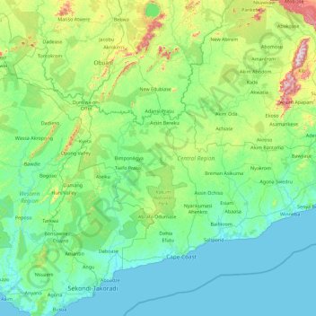
Name: Central Region topographic map, elevation, terrain.
Location: Central Region, Ghana (5.03343 -2.20525 6.29927 -0.40033)
Average elevation: 114 m
Minimum elevation: -1 m
Maximum elevation: 824 m
Other topographic maps
Click on a map to view its topography, its elevation and its terrain.
Atua
Ghana > Western North Region > Aowin Municipal District > Enchi
Atua, Zongo, Enchi, Aowin Municipal District, Western North Region, Ghana
Average elevation: 88 m
Cape Coast
Ghana > Central Region > Cape Coast Metropolitan District
Cape Coast, Cape Coast Metropolitan District, Central Region, Ghana
Average elevation: 22 m
Accra
Ghana > Greater Accra Region > Korle-Klottey Municipal District
Accra, Korle-Klottey Municipal District, Greater Accra Region, Ghana
Average elevation: 31 m