
Thank you for supporting this site ❤️
Make a donation
Make a donation
McCall topographic map
Click on the map to display elevation.
Thank you for supporting this site ❤️
Make a donation
Make a donation
McCall
McCall is located at 44°54′39″N 116°6′11″W / 44.91083°N 116.10306°W / 44.91083; -116.10306 (44.910906, -116.103087), at an elevation of 5,013 feet (1,528 m) above sea level.
Thank you for supporting this site ❤️
Make a donation
Make a donation
About this map
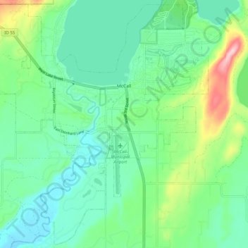
Name: McCall topographic map, elevation, terrain.
Location: McCall, Valley County, Idaho, 83638, United States (44.86605 -116.16411 44.93408 -116.06501)
Average elevation: 1,546 m
Minimum elevation: 1,491 m
Maximum elevation: 1,703 m
Thank you for supporting this site ❤️
Make a donation
Make a donation
Other topographic maps
Click on a map to view its topography, its elevation and its terrain.
Thank you for supporting this site ❤️
Make a donation
Make a donation
Thank you for supporting this site ❤️
Make a donation
Make a donation