
Thank you for supporting this site ❤️
Make a donation
Make a donation
Mae Na topographic map
Click on the map to display elevation.
Thank you for supporting this site ❤️
Make a donation
Make a donation
About this map
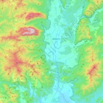
Name: Mae Na topographic map, elevation, terrain.
Location: Mae Na, Chiang Dao District, Chiang Mai Province, Thailand (19.17000 98.79104 19.49000 99.11104)
Average elevation: 765 m
Minimum elevation: 345 m
Maximum elevation: 2,145 m
Thank you for supporting this site ❤️
Make a donation
Make a donation