
Grisons topographic map
Interactive map
Click on the map to display elevation.
About this map
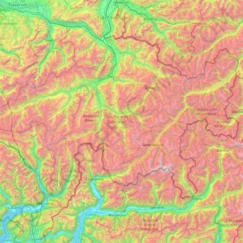
Name: Grisons topographic map, elevation, terrain.
Location: Grisons, Switzerland (46.16918 8.65106 47.06515 10.49229)
Average elevation: 1,737 m
Minimum elevation: 189 m
Maximum elevation: 4,001 m
The Grisons lies fully within the Alps, with elevations above sea-level ranging from 260 to 4,049 metres (853 to 13,284 ft). It is both one of the highest and lowest cantons, and the second-highest when considering mean elevation. As a consequence, its topography is extremely rugged and many of the highest settlements in the country (and Europe) are found there, notably in the Upper Engadin. The mountains are numerous; well over 1,000 summits are in the canton. The highest is Piz Bernina, closely followed by numerous peaks in the homonymous range. Other prominent mountains are Piz Russein, Piz Kesch, Calanda, Aroser Rothorn and Rheinwaldhorn, see list of mountains of Graubünden for a more exhaustive list. The canton includes numerous subranges of the Alps other than the Bernina. These are the Albula, the Bregaglia, the Glarus, the Gotthard, the Lepontine, the Livigno, the Plessur, the Oberhalbstein, the Ortler, the Rätikon, the Samnaun, the Sesvenna and the Silvretta ranges.
Other topographic maps
Click on a map to view its topography, its elevation and its terrain.
Kiental
Switzerland > Bern > Frutigen-Niedersimmental administrative district > Reichenbach im Kandertal
Kiental, Reichenbach im Kandertal, Frutigen-Niedersimmental administrative district, Oberland administrative region, Bern, 3723, Switzerland
Average elevation: 1,363 m
Zurich
Switzerland > Zurich > District Zurich
Zurich, District Zurich, Zurich, Switzerland
Average elevation: 499 m
Besso
Switzerland > Wallis > Anniviers
Besso, Anniviers, Sierre, Wallis, 3961, Switzerland
Average elevation: 2,997 m
La Fouly
Switzerland > Valais/Wallis > La Fouly
La Fouly, Orsières, Entremont, Valais/Wallis, 2303, Switzerland
Average elevation: 2,005 m
Bourg-Saint-Pierre
Switzerland > Valais/Wallis > Bourg-Saint-Pierre
Bourg-Saint-Pierre, Entremont, Valais/Wallis, 1946, Switzerland
Average elevation: 2,530 m
Trub
Switzerland > Bern > Trub
Trub, Verwaltungskreis Emmental, Verwaltungsregion Emmental-Oberaargau, Bern, 3355, Switzerland
Average elevation: 910 m
Amriswil
Switzerland > Thurgau > Amriswil
Amriswil, Bezirk Arbon, Thurgau, Switzerland
Average elevation: 473 m
Islas
Switzerland > Grisons > Zuoz
Islas, Zuoz, Maloja, Grisons, 7524, Switzerland
Average elevation: 1,812 m
Monteggio
Switzerland > Ticino > Monteggio
Monteggio, Circolo di Sessa, Distretto di Lugano, Ticino, Switzerland
Average elevation: 408 m
Fischbach
Switzerland > Thurgau > Fischbach
Fischbach, Bezirk Kreuzlingen, Thurgau, Switzerland
Average elevation: 607 m
Meisterschwanden
Switzerland > Aargau > Meisterschwanden > Bezirk Lenzburg
Meisterschwanden, Bezirk Lenzburg, Aargau, Switzerland
Average elevation: 504 m
Davos
Switzerland > Grisons > Davos
Davos, Prättigau/Davos, Grisons, Switzerland
Average elevation: 2,142 m
Vouvry
Switzerland > Valais/Wallis > Vouvry
Vouvry, Monthey, Valais/Wallis, 1896, Switzerland
Average elevation: 846 m
Avenches
Switzerland > Vaud > Avenches
Avenches, District de la Broye-Vully, Vaud, 1580, Switzerland
Average elevation: 487 m
Bellinzona
Switzerland > Ticino > Bellinzona
Bellinzona, Circolo di Bellinzona, Distretto di Bellinzona, Ticino, Switzerland
Average elevation: 1,083 m
Gundeldingen
Switzerland > Basel-City > Basel
Gundeldingen, Basel, Basel-City, Switzerland
Average elevation: 295 m
Kreuzlingen
Switzerland > Thurgau > Kreuzlingen
Kreuzlingen, Bezirk Kreuzlingen, Thurgau, 8280, Switzerland
Average elevation: 460 m
Tujetsch
Switzerland > Grisons > Tujetsch
Tujetsch, Surselva, Grisons, Switzerland
Average elevation: 2,147 m
Mels
Switzerland > Sankt Gallen > Mels
Mels, Wahlkreis Sarganserland, Sankt Gallen, Switzerland
Average elevation: 1,317 m
Le Chenit
Switzerland > Vaud > Le Chenit
Le Chenit, District du Jura-Nord vaudois, Vaud, Switzerland
Average elevation: 1,239 m
Glacier de Montay
Switzerland > Valais/Wallis > Evolène
Glacier de Montay, Barrage de Ferpècle, Renoillin, Evolène, Hérens, Valais/Wallis, 1983, Switzerland
Average elevation: 2,835 m
Klein Matterhorn
Switzerland > Valais/Wallis > Zermatt
Klein Matterhorn, Zermatt, Visp, Valais/Wallis, 3920, Switzerland
Average elevation: 3,515 m
Lauteraarhorn
Switzerland > Bern > Guttannen
Lauteraarhorn, Guttannen, Verwaltungskreis Interlaken-Oberhasli, Verwaltungsregion Oberland, Bern, 3864, Switzerland
Average elevation: 3,313 m
Breithorn
Switzerland > Valais/Wallis > Blatten
Breithorn, Blatten, Westlich Raron, Valais/Wallis, 3919, Switzerland
Average elevation: 2,914 m
Lugano
Switzerland > Ticino > Lugano
Lugano, Circolo di Lugano ovest, Distretto di Lugano, Ticino, Switzerland
Average elevation: 789 m
Theodulgletscher
Switzerland > Valais/Wallis > Zermatt
Theodulgletscher, Klein Matterhorn, Trockener Steg, Zermatt, Visp, Valais/Wallis, 3920, Switzerland
Average elevation: 3,228 m
Piz Bernina
Switzerland > Grisons > Pontresina
Piz Bernina, Pontresina, Maloja, Grisons, 7504, Switzerland
Average elevation: 3,362 m
Nyon
Switzerland > Vaud > Nyon
Nyon, District de Nyon, Vaud, 1260, Switzerland
Average elevation: 404 m
Bishorn
Switzerland > Valais/Wallis > Turtmann-Unterems
Bishorn, Turtmann-Unterems, Leuk, Valais/Wallis, 3948, Switzerland
Average elevation: 3,597 m
Weisshorn
Switzerland > Valais/Wallis > Randa
Weisshorn, Randa, Visp, Valais/Wallis, 3928, Switzerland
Average elevation: 3,595 m
Glacier de Corbassière
Switzerland > Valais/Wallis > Bourg-Saint-Pierre
Glacier de Corbassière, Spalla Isler, Bourg-Saint-Pierre, Entremont, Valais/Wallis, 1946, Switzerland
Average elevation: 2,940 m
Biosfera Val Müstair
Switzerland > Grisons > Val Müstair
Biosfera Val Müstair, 28, Bain, Val Müstair, Region Engiadina Bassa/Val Müstair, Grisons, 7533, Switzerland
Average elevation: 2,279 m
Säntis
Switzerland > Appenzell Innerrhoden > Schwende
Säntis, Schwende, Appenzell Innerrhoden, 9057, Switzerland
Average elevation: 1,938 m
Schreckhorn
Switzerland > Bern > Grindelwald
Schreckhorn, Grindelwald, Verwaltungskreis Interlaken-Oberhasli, Verwaltungsregion Oberland, Bern, Switzerland
Average elevation: 3,271 m
Haut Glacier d'Arolla
Switzerland > Valais/Wallis > Evolène
Haut Glacier d'Arolla, Evolène, Hérens, Valais/Wallis, 1983, Switzerland
Average elevation: 3,068 m
Eiger
Switzerland > Bern > Lauterbrunnen
Eiger, Lauterbrunnen, Verwaltungskreis Interlaken-Oberhasli, Verwaltungsregion Oberland, Bern, 3801, Switzerland
Average elevation: 2,940 m
Finsteraarhorn
Switzerland > Valais/Wallis > Fieschertal
Finsteraarhorn, Fieschertal, Goms, Valais/Wallis, Switzerland
Average elevation: 3,420 m
Dufourspitze (Monte Rosa)
Switzerland > Valais/Wallis > Zermatt
Dufourspitze (Monte Rosa), Zermatt, Visp, Valais/Wallis, 3920, Switzerland
Average elevation: 4,033 m
Balmhorn
Switzerland > Bern > Kandersteg
Balmhorn, Kandersteg, Verwaltungskreis Frutigen-Niedersimmental, Verwaltungsregion Oberland, Bern, 3718, Switzerland
Average elevation: 2,955 m
Swiss National Park
Switzerland > Grisons > Zernez
Swiss National Park, 28, Punt la Drossa, Zernez, Region Engiadina Bassa/Val Müstair, Grisons, 7530, Switzerland
Average elevation: 2,283 m
Glacier du Mont Miné
Switzerland > Valais/Wallis > Evolène
Glacier du Mont Miné, Arolla - Cabane de la Tsa, Tsijiore Nouve, Evolène, Hérens, Valais/Wallis, 1983, Switzerland
Average elevation: 3,006 m
Lagginhorn
Switzerland > Valais/Wallis > Saas-Grund
Lagginhorn, Saas-Grund, Visp, Valais/Wallis, 3910, Switzerland
Average elevation: 3,342 m
Zumsteinspitze
Switzerland > Valais/Wallis > Zermatt
Zumsteinspitze, Zermatt, Visp, Valais/Wallis, 3920, Switzerland
Average elevation: 4,001 m
Nesthorn
Switzerland > Valais/Wallis > Naters
Nesthorn, Naters, Brig, Valais/Wallis, Switzerland
Average elevation: 3,137 m
Chermignon
Switzerland > Valais/Wallis > Crans
Chermignon, Crans, Sierre, Valais/Wallis, 3971, Switzerland
Average elevation: 1,413 m
Zinalrothorn
Switzerland > Valais/Wallis > Anniviers
Zinalrothorn, Anniviers, Sierre, Valais/Wallis, 3961, Switzerland
Average elevation: 3,514 m