
Mont Aigoual topographic map
Interactive map
Click on the map to display elevation.
About this map
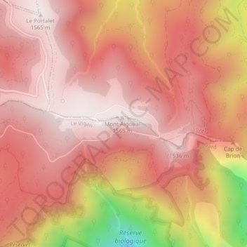
Name: Mont Aigoual topographic map, elevation, terrain.
Average elevation: 1,350 m
Minimum elevation: 776 m
Maximum elevation: 1,561 m
Other topographic maps
Click on a map to view its topography, its elevation and its terrain.
Valleraugue
France > Occitanie > Val-d'Aigoual
Valleraugue, Val-d'Aigoual, Le Vigan, Gard, Occitanie, France métropolitaine, 30570, France
Average elevation: 790 m