
Lafayette topographic map
Interactive map
Click on the map to display elevation.
About this map
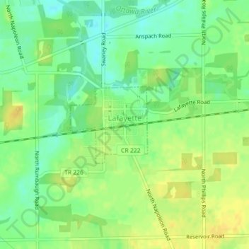
Name: Lafayette topographic map, elevation, terrain.
Location: Lafayette, Allen County, Ohio, 45854, United States (40.75433 -83.95632 40.76262 -83.94526)
Average elevation: 286 m
Minimum elevation: 273 m
Maximum elevation: 297 m
Other topographic maps
Click on a map to view its topography, its elevation and its terrain.
Lima
United States > Ohio > Allen County
Lima, Allen County, Ohio, 45804, United States
Average elevation: 267 m
Spencerville
United States > Ohio > Allen County
Spencerville, Allen County, Ohio, 45887, United States
Average elevation: 254 m
Bluffton
United States > Ohio > Allen County
Bluffton, Allen County, Ohio, 45817, United States
Average elevation: 255 m
Delphos
United States > Ohio > Allen County
Delphos, Allen County, Ohio, 45833, United States
Average elevation: 236 m
South Warsaw
United States > Ohio > Allen County
South Warsaw, Perry Township, Allen County, Ohio, United States
Average elevation: 283 m
Maysville
United States > Ohio > Allen County
Maysville, Jackson Township, Allen County, Ohio, United States
Average elevation: 307 m
Kemp
United States > Ohio > Allen County
Kemp, Allen County, Ohio, United States
Average elevation: 256 m
Landeck
United States > Ohio > Allen County
Landeck, Allen County, Ohio, United States
Average elevation: 242 m
Southworth
United States > Ohio > Allen County
Southworth, Allen County, Ohio, United States
Average elevation: 247 m
Scotts Crossing
United States > Ohio > Allen County
Scotts Crossing, Allen County, Ohio, United States
Average elevation: 239 m
Hume
United States > Ohio > Allen County
Hume, Allen County, Ohio, United States
Average elevation: 260 m
Gomer
United States > Ohio > Allen County
Gomer, Allen County, Ohio, 45809, United States
Average elevation: 237 m
West Newton
United States > Ohio > Allen County
West Newton, Auglaize Township, Allen County, Ohio, United States
Average elevation: 316 m
Rockport
United States > Ohio > Allen County
Rockport, Monroe Township, Allen County, Ohio, 45830, United States
Average elevation: 248 m
Conant
United States > Ohio > Allen County
Conant, Allen County, Ohio, United States
Average elevation: 251 m
Allentown
United States > Ohio > Allen County > Lima
Allentown, Lima, Allen County, Ohio, 45805, United States
Average elevation: 250 m
Westminster
United States > Ohio > Allen County
Westminster, Auglaize Township, Allen County, Ohio, United States
Average elevation: 294 m
Elida
United States > Ohio > Allen County
Elida, Allen County, Ohio, United States
Average elevation: 244 m
Beaverdam
United States > Ohio > Allen County
Beaverdam, Allen County, Ohio, 45808, United States
Average elevation: 264 m
Fort Shawnee
United States > Ohio > Allen County
Fort Shawnee, Allen County, Ohio, 45806, United States
Average elevation: 268 m
Cairo
United States > Ohio > Allen County
Cairo, Allen County, Ohio, 45820, United States
Average elevation: 249 m
Lima
United States > Ohio > Allen County
Lima, Allen County, Ohio, 45804, United States
Average elevation: 267 m
Harrod
United States > Ohio > Allen County
Harrod, Allen County, Ohio, United States
Average elevation: 305 m