
Whiskey Run Beach topographic map
Interactive map
Click on the map to display elevation.
About this map
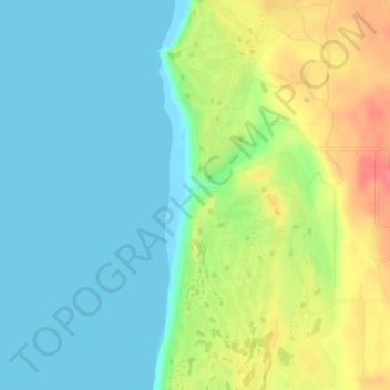
Name: Whiskey Run Beach topographic map, elevation, terrain.
Location: Whiskey Run Beach, Coos County, Oregon, United States (43.21034 -124.39433 43.21044 -124.39423)
Average elevation: 22 m
Minimum elevation: -1 m
Maximum elevation: 65 m
Other topographic maps
Click on a map to view its topography, its elevation and its terrain.
Coquille
United States > Oregon > Coos County
Coquille, Coos County, Oregon, United States
Average elevation: 40 m
North Bend
United States > Oregon > Coos County > North Bend
North Bend, Coos County, Oregon, United States
Average elevation: 11 m
Bandon
United States > Oregon > Coos County
Bandon, Coos County, Oregon, United States
Average elevation: 22 m
Coos Bay
United States > Oregon > Coos County
Coos Bay, Coos County, Oregon, 97420, United States
Average elevation: 30 m