
Maupin topographic map
Interactive map
Click on the map to display elevation.
About this map
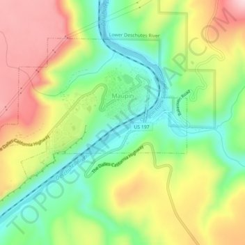
Name: Maupin topographic map, elevation, terrain.
Location: Maupin, Wasco County, Oregon, United States (45.16105 -121.11332 45.18258 -121.06918)
Average elevation: 368 m
Minimum elevation: 242 m
Maximum elevation: 526 m
Other topographic maps
Click on a map to view its topography, its elevation and its terrain.
The Dalles
United States > Oregon > Wasco County
The Dalles, Wasco County, Oregon, United States
Average elevation: 105 m
Dufur
United States > Oregon > Wasco County
Dufur, Wasco County, Oregon, 97021, United States
Average elevation: 445 m