
Murat topographic map
Interactive map
Click on the map to display elevation.
About this map
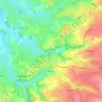
Name: Murat topographic map, elevation, terrain.
Average elevation: 306 m
Minimum elevation: 240 m
Maximum elevation: 402 m
Other topographic maps
Click on a map to view its topography, its elevation and its terrain.
Montluçon
Francia > Auvergne-Rhône-Alpes > Allier > Montluçon
Montluçon, Allier, Auvergne-Rhône-Alpes, Francia metropolitana, 03100, Francia
Average elevation: 256 m