
Nongtrai topographic map
Interactive map
Click on the map to display elevation.
About this map
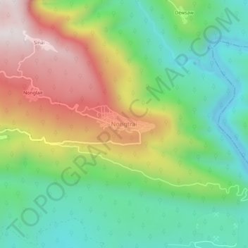
Name: Nongtrai topographic map, elevation, terrain.
Average elevation: 386 m
Minimum elevation: 34 m
Maximum elevation: 938 m
Other topographic maps
Click on a map to view its topography, its elevation and its terrain.
Phlangmawsyrpat
Phlangmawsyrpat, Mawsynram, East Khasi Hills District, Meghalaya, 793113, India
Average elevation: 748 m