
Make a donation
Karsog topographic map
Click on the map to display elevation.
Make a donation
About this map
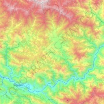
Name: Karsog topographic map, elevation, terrain.
Location: Karsog, Mandi, Himachal Pradesh, India (31.23021 77.04673 31.45304 77.38913)
Average elevation: 1,694 m
Minimum elevation: 604 m
Maximum elevation: 3,316 m
Make a donation
Other topographic maps
Click on a map to view its topography, its elevation and its terrain.
Dharamshala
India > Himachal Pradesh > Dharamshala
The town is located in the Kangra Valley, in the shadow of the Dhauladhar range of the Himalayas at an altitude of 1,457 metres (4,780 ft). References to Dharamshala and its surrounding areas are found in ancient Hindu scriptures such as Rig Veda and Mahabharata. The region was under Mughal influence before it…
Average elevation: 1,781 m
Shimla
Shimla is on the south-western ranges of the Himalayas at 31°37′N 77°06′E / 31.61°N 77.10°E / 31.61; 77.10. It has an average altitude of 2,206 metres (7,238 ft) above mean sea level and extends along a ridge with seven spurs. The city stretches nearly 9.2 kilometres (5.7 mi) from east to west.
Average elevation: 1,557 m
Make a donation
Make a donation
Dharamshala
India > Himachal Pradesh > Dharamshala
Dharamshala has an average elevation of 1,457 m (4,780 ft), covering an area of almost 8.51 km2 (3.29 sq mi). Dharamsala is located in the Kangra Valley, in the shadow of the Dhauladhar mountains.
Average elevation: 1,781 m
Make a donation
Make a donation
Make a donation
Make a donation
Make a donation
Make a donation
Make a donation
Make a donation
Make a donation
Make a donation
Make a donation
Make a donation
Make a donation
Make a donation
Make a donation
Make a donation
Jutogh
India > Himachal Pradesh > Shimla
Jutogh is located at 31°06′N 77°07′E / 31.1°N 77.12°E / 31.1; 77.12 near Totu, an important suburb of Shimla city. It has an average elevation of 1729 metres (5673 feet), a total green area of 112.62 Acres, and a public garden known as Cantt. Board Public Garden.
Average elevation: 1,785 m
Make a donation
Make a donation
Nurpur
India > Himachal Pradesh > Nurpur
Nurpur is located at 32°18′N 75°54′E / 32.3°N 75.9°E / 32.3; 75.9. It has an average elevation of 643 metres (2109 feet).
Average elevation: 536 m
Make a donation
Make a donation
Make a donation
Make a donation
Make a donation