
Les Pielous topographic map
Interactive map
Click on the map to display elevation.
About this map
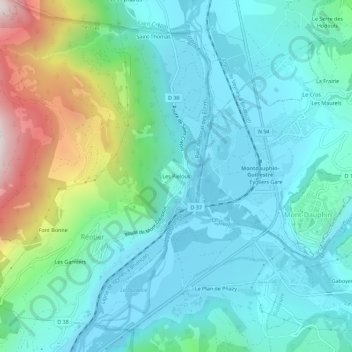
Name: Les Pielous topographic map, elevation, terrain.
Average elevation: 1,067 m
Minimum elevation: 872 m
Maximum elevation: 1,759 m
Other topographic maps
Click on a map to view its topography, its elevation and its terrain.
Saint-Thomas
France > Provence-Alpes-Côte d'Azur > Hautes-Alpes > Réotier
Saint-Thomas, Réotier, Briançon, Hautes-Alpes, Provence-Alpes-Côte d'Azur, Metropolitan France, 05600, France
Average elevation: 1,140 m