
Becket topographic map
Interactive map
Click on the map to display elevation.
About this map
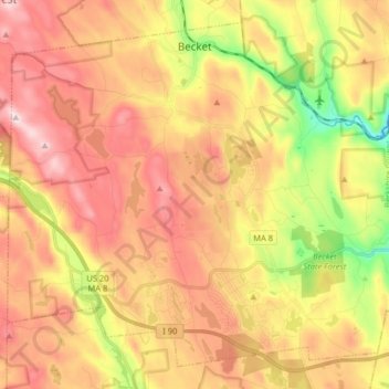
Name: Becket topographic map, elevation, terrain.
Average elevation: 480 m
Minimum elevation: 243 m
Maximum elevation: 671 m
Other topographic maps
Click on a map to view its topography, its elevation and its terrain.
Pittsfield
États-Unis d'Amérique > Massachusetts > Berkshire County
Pittsfield, Berkshire County, Massachusetts, États-Unis d'Amérique
Average elevation: 369 m
Windsor Lake
États-Unis d'Amérique > Massachusetts > Berkshire County > North Adams
Windsor Lake, North Adams, Berkshire County, Massachusetts, États-Unis d'Amérique
Average elevation: 301 m