
Make a donation
Oredo topographic map
Click on the map to display elevation.
Make a donation
About this map
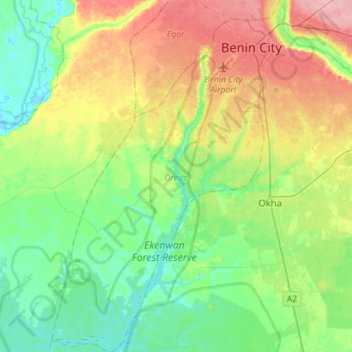
Name: Oredo topographic map, elevation, terrain.
Location: Oredo, Edo State, Nigeria (6.09115 5.46225 6.37050 5.64913)
Average elevation: 38 m
Minimum elevation: 2 m
Maximum elevation: 105 m
Make a donation
Other topographic maps
Click on a map to view its topography, its elevation and its terrain.
Make a donation
Make a donation
Make a donation
Auchi
Nigeria > Edo State > Etsako West
The climate at Auchi, which has an elevation of 0 meters (None feet) above sea level, is tropical wet and dry or savanna (Aw classification). The district's average annual temperature is -0.74% lower than Nigeria's averages at 28.72 °C (83.7 °F). 183.14 millimeters (7.21 inches) of precipitation and 265.4…
Average elevation: 186 m
Make a donation
Make a donation
Make a donation
Auchi
Nigeria > Edo State > Etsako West
The climate at Auchi, which has an elevation of 0 meters (None feet) above sea level, is tropical wet and dry or savanna (Aw classification). The district's average annual temperature is -0.74% lower than Nigeria's averages at 28.72 °C (83.7 °F). 183.14 millimeters (7.21 inches) of precipitation and 265.4…
Average elevation: 186 m
Make a donation