
Manhattan topographic map
Interactive map
Click on the map to display elevation.
About this map
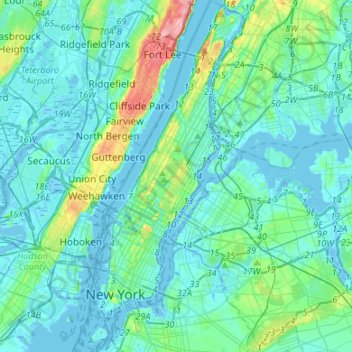
Name: Manhattan topographic map, elevation, terrain.
Location: Manhattan, New York County, New York, États-Unis d'Amérique (40.67965 -74.04721 40.88201 -73.90677)
Average elevation: 16 m
Minimum elevation: -9 m
Maximum elevation: 117 m
Other topographic maps
Click on a map to view its topography, its elevation and its terrain.
Central Park
États-Unis d'Amérique > New York > New York County > New York
Central Park, New York County, New York, États-Unis d'Amérique
Average elevation: 26 m
Liberty Island
États-Unis d'Amérique > New York > New York County > New York
Liberty Island, Manhattan Community Board 1, Manhattan, New York County, New York, Hudson County, New York, États-Unis d'Amérique
Average elevation: 0 m
Battery Park
États-Unis d'Amérique > New York > New York County > New York
Battery Park, Manhattan Community Board 1, Manhattan, New York County, New York, 10004, États-Unis d'Amérique
Average elevation: 3 m