
Thank you for supporting this site ❤️
Make a donation
Make a donation
Jijel topographic map
Click on the map to display elevation.
Thank you for supporting this site ❤️
Make a donation
Make a donation
About this map
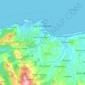
Name: Jijel topographic map, elevation, terrain.
Location: Jijel, Jijel District, Jijel, Algeria (36.76142 5.67602 36.82923 5.82631)
Average elevation: 80 m
Minimum elevation: -3 m
Maximum elevation: 552 m
Thank you for supporting this site ❤️
Make a donation
Make a donation
Other topographic maps
Click on a map to view its topography, its elevation and its terrain.