
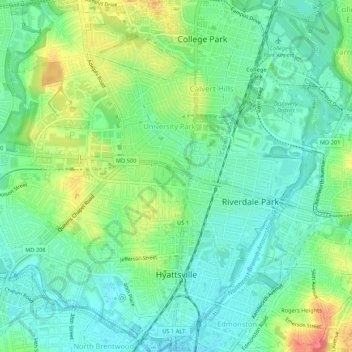
Hyattsville topographic map
Interactive map
Click on the map to display elevation.
About this map
Name: Hyattsville topographic map, elevation, terrain.
Average elevation: 24 m
Minimum elevation: 1 m
Maximum elevation: 69 m
Downtown Hyattsville underwent revitalization in the early 2000s with the development of Arts District Hyattsville, part of the Gateway Arts District, a private project which includes townhomes, live-work units, and retail space. The master developer of the 25-acre neighborhood was Bethesda-based EYA, and was constructed by EYA, PulteGroup, StreetSense, and Bozzuto Group. A Busboys and Poets restaurant opened in July 2011; other retail offerings include Yes! Organic Market, Elevation Burger, Chipotle Mexican Grill, Spice 6 Modern Indian, and Tara Thai. In the winter of 2015, a traveling exhibition platform Visual Collaborative collaborated with the Arts District Hyattsville Master Association, utilizing the Lustine Center to host a group exhibition themed Vanity.
Other topographic maps
Click on a map to view its topography, its elevation and its terrain.
Hillcrest Heights
United States > Maryland > Prince George's County
Hillcrest Heights, Prince George's County, Maryland, 20728, United States
Average elevation: 61 m
National Harbor
United States > Maryland > Prince George's County
National Harbor, Prince George's County, Maryland, 20745, United States
Average elevation: 24 m
Greenbelt Park
United States > Maryland > Prince George's County > Greenbelt
Greenbelt Park, 6565, Greenbelt, Prince George's County, Maryland, 20770, United States
Average elevation: 40 m
Temple Hills
United States > Maryland > Prince George's County
Temple Hills, Prince George's County, Maryland, 20748, United States
Average elevation: 66 m
Upper Marlboro
United States > Maryland > Prince George's County
Upper Marlboro, Prince George's County, Maryland, United States
Average elevation: 19 m
Sellman Estates
United States > Maryland > Prince George's County > Beltsville
Sellman Estates, Beltsville, Prince George's County, Maryland, 20705, United States
Average elevation: 61 m
White Hall
United States > Maryland > Prince George's County
White Hall, Prince George's County, Maryland, 20607, United States
Average elevation: 36 m
Langley Park
United States > Maryland > Prince George's County > Langley Park
Langley Park, Prince George's County, Maryland, 20783, United States
Average elevation: 53 m
Summerfield
United States > Maryland > Prince George's County
Summerfield, Prince George's County, Maryland, 20785, United States
Average elevation: 49 m
Brandywine
United States > Maryland > Prince George's County
Brandywine, Prince George's County, Maryland, 20613, United States
Average elevation: 61 m
Suitland
United States > Maryland > Prince George's County
Suitland, Prince George's County, Maryland, 20233, United States
Average elevation: 70 m
Camp Springs
United States > Maryland > Prince George's County > Camp Springs
Camp Springs, Prince George's County, Maryland, 20746, United States
Average elevation: 72 m
Landover
United States > Maryland > Prince George's County > Landover
Landover, Prince George's County, Maryland, 20785, United States
Average elevation: 38 m
Cheverly
United States > Maryland > Prince George's County
Cheverly, Prince George's County, Maryland, United States
Average elevation: 29 m
Buck Lodge
United States > Maryland > Prince George's County > Adelphi
Buck Lodge, Adelphi, Prince George's County, Maryland, 20993, United States
Average elevation: 59 m
Capitol Heights
United States > Maryland > Prince George's County
Capitol Heights, Prince George's County, Maryland, United States
Average elevation: 64 m
Mitchellville
United States > Maryland > Prince George's County > Mitchellville
Mitchellville, Prince George's County, Maryland, United States
Average elevation: 46 m
Lanham
United States > Maryland > Prince George's County > Glenn Dale
Lanham, Glenn Dale, Prince George's County, Maryland, 20706, United States
Average elevation: 47 m
Seabrook
United States > Maryland > Prince George's County > Glenn Dale
Seabrook, Glenn Dale, Prince George's County, Maryland, 20070, United States
Average elevation: 49 m
Konterra
United States > Maryland > Prince George's County > Konterra
Konterra, Prince George's County, Maryland, United States
Average elevation: 86 m
Auburn
United States > Maryland > Prince George's County > Auburn
Auburn, Prince George's County, Maryland, 2060, United States
Average elevation: 36 m
Silesia
United States > Maryland > Prince George's County > Silesia
Silesia, Prince George's County, Maryland, 20744, United States
Average elevation: 27 m
Farmington Road Estates
United States > Maryland > Prince George's County > Farmington Road Estates
Farmington Road Estates, Prince George's County, Maryland, 2060, United States
Average elevation: 47 m
Mount Rainier Neighborhood Park
United States > Maryland > Prince George's County > Mount Rainier
Mount Rainier Neighborhood Park, Queenstown, Mount Rainier, Prince George's County, Maryland, 20712, United States
Average elevation: 21 m
Adelphi
United States > Maryland > Prince George's County
Adelphi, Prince George's County, Maryland, United States
Average elevation: 56 m
Bowie
United States > Maryland > Prince George's County
Bowie, Prince George's County, Maryland, United States
Average elevation: 38 m
Clinton
United States > Maryland > Prince George's County > Clinton
Clinton, Prince George's County, Maryland, 20735, United States
Average elevation: 64 m
Laurel
United States > Maryland > Prince George's County
Laurel, Prince George's County, Maryland, 20707, United States
Average elevation: 73 m
College Park
United States > Maryland > Prince George's County
College Park, Prince George's County, Maryland, United States
Average elevation: 38 m