
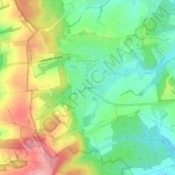
Winterbach topographic map
Interactive map
Click on the map to display elevation.
About this map
Name: Winterbach topographic map, elevation, terrain.
Average elevation: 340 m
Minimum elevation: 285 m
Maximum elevation: 419 m
Other topographic maps
Click on a map to view its topography, its elevation and its terrain.
Oberlinxweiler
Deutschland > Saarland > Landkreis St. Wendel > Sankt Wendel
Oberlinxweiler, Sankt Wendel, Landkreis St. Wendel, Saarland, Deutschland
Average elevation: 310 m
Remmesweiler
Deutschland > Saarland > Landkreis St. Wendel > Sankt Wendel
Remmesweiler, Sankt Wendel, Landkreis St. Wendel, Saarland, Deutschland
Average elevation: 330 m
Bliesen
Deutschland > Saarland > Landkreis St. Wendel > Sankt Wendel > Bliesen
Bliesen, Sankt Wendel, Landkreis St. Wendel, Saarland, Deutschland
Average elevation: 327 m