
Make a donation
Déline topographic map
Click on the map to display elevation.
Make a donation
About this map
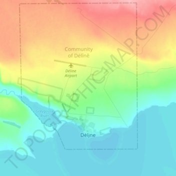
Name: Déline topographic map, elevation, terrain.
Average elevation: 193 m
Minimum elevation: 155 m
Maximum elevation: 262 m
Make a donation
Other topographic maps
Click on a map to view its topography, its elevation and its terrain.
Mackenzie River
Canada > Northwest Territories > Sahtu Region
The Mackenzie widens considerably to about 6 to 7 kilometres (3.7 to 4.3 mi) at Norman Wells, a major centre of oil production. There is a narrows at the Mountain River confluence called the Sans Sault Rapids, where the Mackenzie falls about 6 metres (20 ft). Below the Mountain River the Mackenzie flows due…
Average elevation: 206 m
Make a donation
Mackenzie River
Canada > Northwest Territories > Sahtu Region
The Mackenzie widens considerably to about 6 to 7 kilometres (3.7 to 4.3 mi) at Norman Wells, a major centre of oil production. There is a narrows at the Mountain River confluence called the Sans Sault Rapids, where the Mackenzie falls about 6 metres (20 ft). Below the Mountain River the Mackenzie flows due…
Average elevation: 97 m