
Buford topographic map
Interactive map
Click on the map to display elevation.
About this map
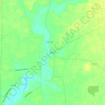
Name: Buford topographic map, elevation, terrain.
Location: Buford, Highland County, Ohio, United States (39.05673 -83.86409 39.09673 -83.82409)
Average elevation: 293 m
Minimum elevation: 282 m
Maximum elevation: 302 m
Other topographic maps
Click on a map to view its topography, its elevation and its terrain.
Sinking Spring
United States > Ohio > Highland County
Sinking Spring, Highland County, Ohio, 45172, United States
Average elevation: 267 m
Berrysville
United States > Ohio > Highland County
Berrysville, Highland County, Ohio, 45133, United States
Average elevation: 310 m
New Petersburg
United States > Ohio > Highland County
New Petersburg, Highland County, Ohio, United States
Average elevation: 288 m
Mowrystown
United States > Ohio > Highland County
Mowrystown, Highland County, Ohio, 45155, United States
Average elevation: 299 m
Elmville
United States > Ohio > Highland County
Elmville, Highland County, Ohio, United States
Average elevation: 255 m
Pricetown
United States > Ohio > Highland County
Pricetown, Highland County, Ohio, United States
Average elevation: 312 m
Allensburg
United States > Ohio > Highland County
Allensburg, Highland County, Ohio, 45142, United States
Average elevation: 313 m
Belfast
United States > Ohio > Highland County
Belfast, Highland County, Ohio, United States
Average elevation: 267 m
Boston
United States > Ohio > Highland County
Boston, Highland County, Ohio, United States
Average elevation: 306 m
Fairfax
United States > Ohio > Highland County
Fairfax, Highland County, Ohio, United States
Average elevation: 307 m
East Danville
United States > Ohio > Highland County
East Danville, Highland County, Ohio, United States
Average elevation: 319 m
Dodsonville
United States > Ohio > Highland County
Dodsonville, Highland County, Ohio, 45142, United States
Average elevation: 309 m
Folsom
United States > Ohio > Highland County
Folsom, Highland County, Ohio, United States
Average elevation: 291 m
Hoagland
United States > Ohio > Highland County
Hoagland, Highland County, Ohio, United States
Average elevation: 334 m
Hollowtown
United States > Ohio > Highland County
Hollowtown, Highland County, Ohio, United States
Average elevation: 312 m
Marshall
United States > Ohio > Highland County
Marshall, Highland County, Ohio, United States
Average elevation: 299 m
New Market
United States > Ohio > Highland County
New Market, Highland County, Ohio, United States
Average elevation: 338 m
Sugar Tree Ridge
United States > Ohio > Highland County
Sugar Tree Ridge, Highland County, Ohio, United States
Average elevation: 324 m
Taylorsville
United States > Ohio > Highland County
Taylorsville, Highland County, Ohio, 45155, United States
Average elevation: 306 m
Carmel
United States > Ohio > Highland County
Carmel, Highland County, Ohio, United States
Average elevation: 304 m
Fallsville State Wildlife Area
United States > Ohio > Highland County
Fallsville State Wildlife Area, Highland County, Ohio, United States
Average elevation: 339 m
Rainsboro
United States > Ohio > Highland County
Rainsboro, Highland County, Ohio, United States
Average elevation: 283 m
East Monroe
United States > Ohio > Highland County
East Monroe, Highland County, Ohio, 45135, United States
Average elevation: 297 m
Highland
United States > Ohio > Highland County
Highland, Highland County, Ohio, 45132, United States
Average elevation: 326 m
Samantha
United States > Ohio > Highland County
Samantha, Highland County, Ohio, United States
Average elevation: 345 m
Hillsboro
United States > Ohio > Highland County
Hillsboro, Highland County, Ohio, United States
Average elevation: 313 m
Lynchburg
United States > Ohio > Highland County
Lynchburg, Highland County, Ohio, United States
Average elevation: 310 m
Paint Creek Lake
United States > Ohio > Highland County
Paint Creek Lake, Highland County, Ohio, United States
Average elevation: 277 m
Rocky Fork Lake
United States > Ohio > Highland County
Rocky Fork Lake, Highland County, Ohio, United States
Average elevation: 291 m
Greenfield
United States > Ohio > Highland County
Greenfield, Highland County, Ohio, United States
Average elevation: 276 m
Paint Creek State Park
United States > Ohio > Highland County
Paint Creek State Park, Highland County, Ohio, United States
Average elevation: 271 m
Leesburg
United States > Ohio > Highland County
Leesburg, Highland County, Ohio, United States
Average elevation: 313 m