Geolocate

Sint Eustatius topographic map

Interactive map

Click on the map to display elevation.

About this map

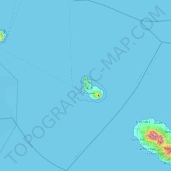
Name: Sint Eustatius topographic map, elevation, terrain.

Location: Sint Eustatius, Netherlands (17.27673 -63.19861 17.72699 -62.78471)

Average elevation: 12 m

Minimum elevation: 0 m

Maximum elevation: 1,044 m

Sint Eustatius is 6 miles (10 km) long and up to 3 miles (5 km) wide. Topographically, the island is saddle-shaped, with the 602-meter-high dormant volcano Quill (Mount Mazinga), (from Dutch kuil, meaning 'pit'—originally referring to its crater) to the southeast and the smaller summits of Signal Hill/Little Mountain (or Bergje) and Boven Mountain to the northwest. The Quill crater is a popular tourist attraction on the island. The bulk of the island's population lives in the flat saddle between the two elevated areas, which forms the centre of the island.

Wikipedia (CC-BY-SA 3.0)

Other topographic maps

Click on a map to view its topography, its elevation and its terrain.

Saba

Netherlands

Saba, Netherlands

Average elevation: 2 m

Leiden

Netherlands > South Holland

Leiden, South Holland, Netherlands

Average elevation: 1 m

Aruba

Netherlands

Aruba, Netherlands

Average elevation: 11 m

Rincon

Netherlands

Rincon, Bonaire, Netherlands

Average elevation: 40 m

Curaçao

Netherlands

Curaçao, Curacao, Netherlands

Average elevation: 7 m

Sint-Michielsgestel

Netherlands > North Brabant

Sint-Michielsgestel, North Brabant, Netherlands

Average elevation: 7 m

Enschede

Netherlands > Overijssel > Enschede

Enschede, Overijssel, Netherlands

Average elevation: 38 m

Maarssen

Netherlands > Utrecht > Stichtse Vecht

Maarssen, Stichtse Vecht, Utrecht, Netherlands

Average elevation: 1 m

Uden

Netherlands > North Brabant > Uden

Uden, North Brabant, Netherlands

Average elevation: 17 m

Huizen

Netherlands > North Holland > Huizen

Huizen, North Holland, Netherlands

Average elevation: 3 m

Hof van Twente

Netherlands > Overijssel > Hof van Twente

Hof van Twente, Overijssel, Netherlands

Average elevation: 16 m

Eindhoven

Netherlands > North Brabant > Eindhoven

Eindhoven, North Brabant, Netherlands

Average elevation: 20 m

Driehuizen

Netherlands > North Brabant > Driehuizen

Driehuizen, North Brabant, Netherlands, 5111, Netherlands

Average elevation: 26 m

Camping

Netherlands > Friesland > De Fryske Marren

Camping, De Fryske Marren, Friesland, Netherlands, 8493KN, Netherlands

Average elevation: -1 m

Julianadorp

Netherlands > North Holland > Den Helder

Julianadorp, Den Helder, North Holland, Netherlands

Average elevation: 1 m

Nuenen

Netherlands > North Brabant > Nuenen c.a.

Nuenen, Nuenen c.a., North Brabant, Netherlands

Average elevation: 17 m

Batenburg

Netherlands > Gelderland > Wijchen

Batenburg, Wijchen, Gelderland, Netherlands

Average elevation: 8 m

Arnhem

Netherlands > Gelderland > Arnhem

Arnhem, Gelderland, Netherlands

Average elevation: 36 m

Naarden

Netherlands > North Holland > Gooise Meren

Naarden, Gooise Meren, North Holland, Netherlands

Average elevation: 2 m

Rotterdam

Netherlands > South Holland > Rotterdam

Rotterdam, South Holland, Netherlands

Average elevation: 0 m

Hoogerheide

Netherlands > North Brabant > Woensdrecht

Hoogerheide, Woensdrecht, North Brabant, Netherlands

Average elevation: 14 m

North Holland

Netherlands

North Holland, Netherlands

Average elevation: 0 m

South Holland

Netherlands

South Holland, Netherlands

Average elevation: 0 m

Horst aan de Maas

Netherlands > Limburg > Horst aan de Maas

Horst aan de Maas, Limburg, Netherlands

Average elevation: 27 m

Zoetermeer

Netherlands > South Holland > Zoetermeer

Zoetermeer, South Holland, Netherlands

Average elevation: -3 m

Noordoostpolder

Netherlands > Flevoland > Noordoostpolder

Noordoostpolder, Flevoland, Netherlands

Average elevation: -1 m

Limburg

Netherlands

Limburg, Netherlands

Average elevation: 49 m

Eindhoven

Netherlands > North Brabant > Eindhoven

Eindhoven, North Brabant, Netherlands

Average elevation: 20 m