
Les Andelys topographic map
Interactive map
Click on the map to display elevation.
About this map
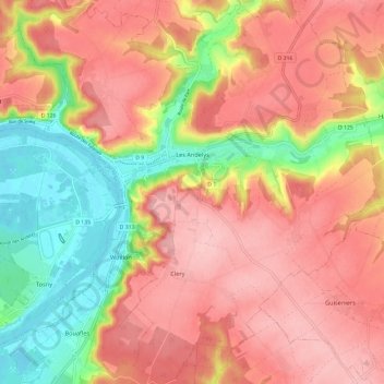
Name: Les Andelys topographic map, elevation, terrain.
Location: Les Andelys, Eure, Normandy, Metropolitan France, 27700, France (49.20027 1.36759 49.27812 1.48040)
Average elevation: 100 m
Minimum elevation: 7 m
Maximum elevation: 164 m
Other topographic maps
Click on a map to view its topography, its elevation and its terrain.
Val-de-Reuil
Val-de-Reuil, Les Andelys, Eure, Normandy, Metropolitan France, 27100, France
Average elevation: 42 m
Mandeville
Mandeville, Bernay, Eure, Normandy, Metropolitan France, 27370, France
Average elevation: 157 m