
บ้านหนองยาว topographic map
Interactive map
Click on the map to display elevation.
About this map
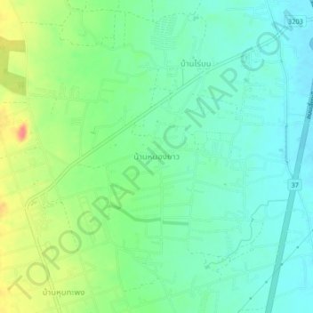
Name: บ้านหนองยาว topographic map, elevation, terrain.
Location: บ้านหนองยาว, นายาง, Phetchaburi, Thailand (12.77384 99.90169 12.81384 99.94169)
Average elevation: 31 m
Minimum elevation: 11 m
Maximum elevation: 73 m
Other topographic maps
Click on a map to view its topography, its elevation and its terrain.
หาดชะอำ
Thailand > Phetchaburi > สามพระยา > ชะอำ
หาดชะอำ, ชะอำ, นายาง, สามพระยา, Phetchaburi, Thailand
Average elevation: 3 m