
Gutenberg topographic map
Interactive map
Click on the map to display elevation.
About this map
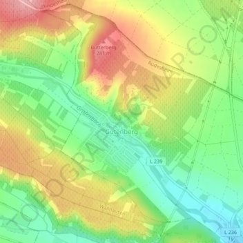
Name: Gutenberg topographic map, elevation, terrain.
Average elevation: 214 m
Minimum elevation: 150 m
Maximum elevation: 292 m
Other topographic maps
Click on a map to view its topography, its elevation and its terrain.
Langenlonsheim
Germany > Rhineland-Palatinate > Landkreis Bad Kreuznach
Langenlonsheim, Langenlonsheim-Stromberg, Landkreis Bad Kreuznach, Rhineland-Palatinate, Germany
Average elevation: 135 m
Sponheim
Germany > Rhineland-Palatinate > Landkreis Bad Kreuznach
Sponheim, Rüdesheim, Landkreis Bad Kreuznach, Rhineland-Palatinate, Germany
Average elevation: 280 m
Meddersheim
Germany > Rhineland-Palatinate > Landkreis Bad Kreuznach
Meddersheim, Nahe-Glan, Landkreis Bad Kreuznach, Rhineland-Palatinate, Germany
Average elevation: 228 m
Seesbach
Germany > Rhineland-Palatinate > Landkreis Bad Kreuznach
Seesbach, Nahe-Glan, Landkreis Bad Kreuznach, Rhineland-Palatinate, 55629, Germany
Average elevation: 385 m
Bad Kreuznach
Germany > Rhineland-Palatinate > Landkreis Bad Kreuznach
Bad Kreuznach, Landkreis Bad Kreuznach, Rhineland-Palatinate, Germany
Average elevation: 180 m
Kirn
Germany > Rhineland-Palatinate > Landkreis Bad Kreuznach
Kirn, Kirner Land, Landkreis Bad Kreuznach, Rhineland-Palatinate, Germany
Average elevation: 302 m
Dörrebach
Germany > Rhineland-Palatinate > Landkreis Bad Kreuznach
Dörrebach, Langenlonsheim-Stromberg, Landkreis Bad Kreuznach, Rhineland-Palatinate, 55444, Germany
Average elevation: 410 m