
Thank you for supporting this site ❤️
Make a donation
Make a donation
Sikka topographic map
Click on the map to display elevation.
Thank you for supporting this site ❤️
Make a donation
Make a donation
About this map
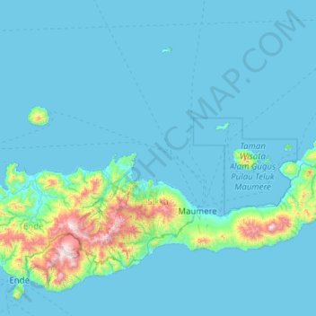
Name: Sikka topographic map, elevation, terrain.
Location: Sikka, East Nusa Tenggara, Lesser Sunda Islands, Indonesia (-8.80739 121.67542 -8.10644 122.68687)
Average elevation: 117 m
Minimum elevation: 0 m
Maximum elevation: 1,666 m
Thank you for supporting this site ❤️
Make a donation
Make a donation
Other topographic maps
Click on a map to view its topography, its elevation and its terrain.
Thank you for supporting this site ❤️
Make a donation
Make a donation
Thank you for supporting this site ❤️
Make a donation
Make a donation
Thank you for supporting this site ❤️
Make a donation
Make a donation
Thank you for supporting this site ❤️
Make a donation
Make a donation
Thank you for supporting this site ❤️
Make a donation
Make a donation
Thank you for supporting this site ❤️
Make a donation
Make a donation
Gili Lawa Darat Island
Indonesia > East Nusa Tenggara > Manggarai Barat > Komodo
Average elevation: 13 m
Thank you for supporting this site ❤️
Make a donation
Make a donation
View over the lake (behind wall)
Indonesia > East Nusa Tenggara > Manggarai Timur > Ranaka
Average elevation: 1,365 m
Pantai Ratenggaro (Beach)
Indonesia > East Nusa Tenggara > Sumba Barat Daya > Bondokodi
Average elevation: 12 m
Thank you for supporting this site ❤️
Make a donation
Make a donation
Thank you for supporting this site ❤️
Make a donation
Make a donation
Thank you for supporting this site ❤️
Make a donation
Make a donation
Pasunga Cultural Village
Indonesia > East Nusa Tenggara > Sumba Tengah > Pasunga Cultural Village
Average elevation: 450 m
Thank you for supporting this site ❤️
Make a donation
Make a donation