
Bittkau topographic map
Interactive map
Click on the map to display elevation.
About this map
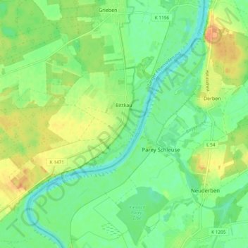
Name: Bittkau topographic map, elevation, terrain.
Location: Bittkau, Tangerhütte, Stendal, Sachsen-Anhalt, Deutschland (52.39494 11.88751 52.42346 11.98144)
Average elevation: 40 m
Minimum elevation: 25 m
Maximum elevation: 59 m
Other topographic maps
Click on a map to view its topography, its elevation and its terrain.
Uchtdorf
Deutschland > Sachsen-Anhalt > Stendal > Tangerhütte
Uchtdorf, Tangerhütte, Stendal, Sachsen-Anhalt, Deutschland
Average elevation: 48 m
Groß Schwarzlosen
Deutschland > Sachsen-Anhalt > Stendal > Tangerhütte
Groß Schwarzlosen, Tangerhütte, Stendal, Sachsen-Anhalt, Deutschland
Average elevation: 50 m
Demker
Deutschland > Sachsen-Anhalt > Stendal > Tangerhütte
Demker, Tangerhütte, Stendal, Sachsen-Anhalt, Deutschland
Average elevation: 43 m
Waldfrieden
Deutschland > Sachsen-Anhalt > Stendal > Tangerhütte > Birkholz
Waldfrieden, Birkholz, Tangerhütte, Stendal, Sachsen-Anhalt, Deutschland
Average elevation: 40 m
Schelldorf
Deutschland > Sachsen-Anhalt > Stendal > Tangerhütte > Schelldorf
Schelldorf, Tangerhütte, Stendal, Sachsen-Anhalt, Deutschland
Average elevation: 35 m