
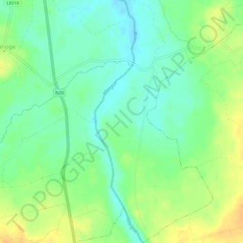
Inchinclare topographic map
Interactive map
Click on the map to display elevation.
About this map
Name: Inchinclare topographic map, elevation, terrain.
Average elevation: 41 m
Minimum elevation: 28 m
Maximum elevation: 57 m
Other topographic maps
Click on a map to view its topography, its elevation and its terrain.
Knocknabooly East
Ireland > The Municipal District of Adare — Rathkeale
Knocknabooly East, Loghill, The Municipal District of Adare — Rathkeale, County Limerick, Munster, Ireland
Average elevation: 105 m
Glendiheen
Ireland > The Municipal District of Adare — Rathkeale
Glendiheen, Dunmoylan East, The Municipal District of Adare — Rathkeale, County Limerick, Munster, Ireland
Average elevation: 167 m
Shanagolden
Ireland > The Municipal District of Adare — Rathkeale
Shanagolden, The Municipal District of Adare — Rathkeale, County Limerick, Munster, Ireland
Average elevation: 40 m
Pallaskenry
Ireland > The Municipal District of Adare — Rathkeale
Pallaskenry, The Municipal District of Adare — Rathkeale, County Limerick, Munster, Ireland
Average elevation: 11 m
Loghill
Ireland > The Municipal District of Adare — Rathkeale
Loghill, The Municipal District of Adare — Rathkeale, County Limerick, Munster, Ireland
Average elevation: 69 m
Ballinknockane
Ireland > The Municipal District of Adare — Rathkeale
Ballinknockane, Craggs, The Municipal District of Adare — Rathkeale, County Limerick, Munster, Ireland
Average elevation: 27 m
Clonshire Beg
Ireland > The Municipal District of Adare — Rathkeale
Clonshire Beg, Croagh, The Municipal District of Adare — Rathkeale, County Limerick, Munster, Ireland
Average elevation: 13 m
Foynes Island
Ireland > The Municipal District of Adare — Rathkeale
Foynes Island, Shanagolden, The Municipal District of Adare — Rathkeale, County Limerick, Munster, Ireland
Average elevation: 10 m
Kildimo
Ireland > The Municipal District of Adare — Rathkeale
Kildimo, The Municipal District of Adare — Rathkeale, County Limerick, Munster, Ireland
Average elevation: 14 m