
Le Vivray topographic map
Interactive map
Click on the map to display elevation.
About this map
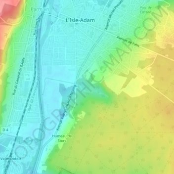
Name: Le Vivray topographic map, elevation, terrain.
Average elevation: 53 m
Minimum elevation: 22 m
Maximum elevation: 112 m
Other topographic maps
Click on a map to view its topography, its elevation and its terrain.
Hameau de Stors
France > Île-de-France > L'Isle-Adam > Hameau de Stors
Hameau de Stors, L'Isle-Adam, Pontoise, Val-d'Oise, Île-de-France, France métropolitaine, 95290, France
Average elevation: 61 m