
Makkah Region topographic map
Interactive map
Click on the map to display elevation.
About this map
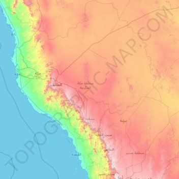
Name: Makkah Region topographic map, elevation, terrain.
Location: Makkah Region, Saudi Arabia (18.28122 38.65977 23.69520 43.83016)
Average elevation: 785 m
Minimum elevation: -4 m
Maximum elevation: 2,910 m
Most of the central and eastern portions of the province are desert, with the Hejaz mountains, which vary in elevation from 600 meters to 2000 meters, separating the relatively flat Nafud desert and coastal plains. Agriculture takes place in the region's many wadis and oases, with the most commonly-grown crops being dates and barley, alongside other vegetables and fruits. The city of Ta'if is famous for its cultivation of the Rosa × damascena flower, simplified as Damask rose and locally known as Ta'if rose.
Other topographic maps
Click on a map to view its topography, its elevation and its terrain.
Riyadh Al Khabra
Saudi Arabia > Al-Qassim Province
Riyadh Al Khabra, Al-Qassim Province, Saudi Arabia
Average elevation: 886 m
Makkah Al Mukarramah
Makkah Al Mukarramah, Makkah Region, Saudi Arabia
Average elevation: 479 m
At Ta'if
At Ta'if, Al Taif, Makkah Region, 26511, Saudi Arabia
Average elevation: 1,742 m
AlUla
Saudi Arabia > Medina Province
AlUla, Al Ula, Medina Province, Saudi Arabia
Average elevation: 748 m
Dammam
Saudi Arabia > Eastern Region > Dammam
Dammam, Eastern Region, 31451, Saudi Arabia
Average elevation: 9 m
Al Udayd Governorate
Saudi Arabia > Eastern Region > Al Udayd Governorate
Al Udayd Governorate, Eastern Region, 36621, Saudi Arabia
Average elevation: 133 m
Murshidiyah
Murshidiyah, Makkah Region, 21955, Saudi Arabia
Average elevation: 326 m
King Fahad
King Fahad, At Taif, Makkah Region, Saudi Arabia
Average elevation: 1,709 m