
Make a donation
High Shincliffe topographic map
Click on the map to display elevation.
Make a donation
High Shincliffe
High Shincliffe is a village in County Durham, England. It is situated about two miles south-east of Durham City, on the A177 road to Stockton-on-Tees. The altitude of High Shincliffe is approximately 90 metres (300 ft), and it lies 55 metres (180 ft) above the River Wear at Shincliffe bridge. Latest population figures are available from the 2011 Census.
Make a donation
About this map
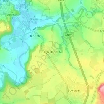
Name: High Shincliffe topographic map, elevation, terrain.
Average elevation: 77 m
Minimum elevation: 32 m
Maximum elevation: 162 m
Make a donation
Other topographic maps
Click on a map to view its topography, its elevation and its terrain.
Make a donation
Make a donation
Make a donation
South Agnew Plantation
United Kingdom > England > County Durham > Newton Aycliffe
Average elevation: 100 m
Make a donation
Make a donation
Make a donation
Make a donation
Make a donation
Make a donation
Make a donation
Make a donation
Make a donation
Make a donation
Make a donation
Make a donation
Make a donation
Make a donation
Make a donation
Make a donation
Make a donation
Make a donation
Oakey's Park
United Kingdom > England > County Durham > Stanley > West Shield Row Villas
Average elevation: 182 m
Make a donation
Flass Vale Local Nature Reserve
United Kingdom > England > County Durham > Durham
Average elevation: 81 m
Bishop Middleham Quarry Nature Reserve
United Kingdom > England > County Durham > Bishop Middleham
Average elevation: 115 m
Tunstall Reservoir
United Kingdom > England > County Durham > Wolsingham
The reservoir was created for the Weardale and Shildon District Waterworks Company, with construction of the dam between 1873 and 1879.[2][3] The earth embankment dam was built across the valley of Waskerley Beck, and measures 1,020 feet (310 m) long and 82 feet (25 m) high. It was constructed with a puddle…
Average elevation: 288 m
Make a donation
Make a donation
Make a donation