
Sequoyah County topographic map
Interactive map
Click on the map to display elevation.
About this map
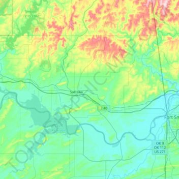
Name: Sequoyah County topographic map, elevation, terrain.
Location: Sequoyah County, Oklahoma, USA (35.29042 -95.13422 35.63963 -94.43122)
Average elevation: 212 m
Minimum elevation: 120 m
Maximum elevation: 582 m
Other topographic maps
Click on a map to view its topography, its elevation and its terrain.
Locust Grove
USA > Oklahoma > Locust Grove
Locust Grove, Mayes County, Oklahoma, 74352, USA
Average elevation: 213 m
Razorback Mountain
Razorback Mountain, Pushmataha County, Oklahoma, 74557, USA
Average elevation: 231 m