
Hải Phòng topographic map
Interactive map
Click on the map to display elevation.
About this map
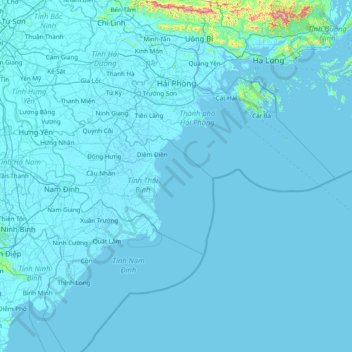
Name: Hải Phòng topographic map, elevation, terrain.
Location: Hải Phòng, Vietnam (19.92658 106.40055 21.02029 107.95112)
Average elevation: 16 m
Minimum elevation: -3 m
Maximum elevation: 995 m
Other topographic maps
Click on a map to view its topography, its elevation and its terrain.
Ho Chi Minh City
Vietnam > Ho Chi Minh City > Ho Chi Minh City
Ho Chi Minh City, District 1, Ho Chi Minh City, 00084, Vietnam
Average elevation: 6 m
Tay Thanh Ward
Vietnam > Ho Chi Minh City > Tay Thanh Ward > Tan Phu District
Tay Thanh Ward, Tan Phu District, Ho Chi Minh City, Vietnam
Average elevation: 6 m
Vân Đồn District
Vân Đồn District, Quang Ninh Province, 20000, Vietnam
Average elevation: 24 m
Phu Quoc Island
Phu Quoc Island, Phu Quoc, Phu Quoc Island, Vietnam
Average elevation: 17 m