
Make a donation
Utah topographic map
Click on the map to display elevation.
Make a donation
Utah
Western Utah is mostly arid desert with a basin and range topography. Small mountain ranges and rugged terrain punctuate the landscape. The Bonneville Salt Flats are an exception, being comparatively flat as a result of once forming the bed of ancient Lake Bonneville. Great Salt Lake, Utah Lake, Sevier Lake, and Rush Lake are all remnants of this ancient freshwater lake, which once covered most of the eastern Great Basin. West of the Great Salt Lake, stretching to the Nevada border, lies the arid Great Salt Lake Desert. One exception to this aridity is Snake Valley, which is (relatively) lush due to large springs and wetlands fed from groundwater derived from snow melt in the Snake Range, Deep Creek Range, and other tall mountains to the west of Snake Valley. Great Basin National Park is just over the Nevada state line in the southern Snake Range. One of western Utah's most impressive, but least visited attractions is Notch Peak, the tallest limestone cliff in North America, located west of Delta.
Make a donation
About this map
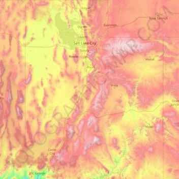
Name: Utah topographic map, elevation, terrain.
Location: Utah, United States (36.99781 -114.05285 42.00170 -109.04158)
Average elevation: 1,876 m
Minimum elevation: 789 m
Maximum elevation: 3,986 m
Make a donation
Other topographic maps
Click on a map to view its topography, its elevation and its terrain.
Make a donation
Fern Glen
United States > Pennsylvania > Luzerne County > Black Creek Township
Average elevation: 391 m
Make a donation
Trachsville
United States > Pennsylvania > Carbon County > Towamensing Township
Average elevation: 256 m
Make a donation
Make a donation
Make a donation
Cleveland
United States > Ohio > Cuyahoga County > Cleveland
The land rises quickly from the lake shore elevation of 569 feet. Public Square, less than one mile (1.6 km) inland, sits at an elevation of 650 feet (198 m), and Hopkins Airport, 5 miles (8 km) inland from the lake, is at an elevation of 791 feet (241 m).
Average elevation: 219 m
Make a donation
Glen Canyon Dam
United States > Arizona > Coconino County
The Bureau of Reclamation favored the Echo Park site over Glen Canyon, because its narrow canyons and high elevation (more than 5,000 feet (1,500 m), as compared to 3,700 feet (1,100 m) at Glen Canyon) would lead to less evaporation. It said that building Echo Park Dam and a "low" Glen Canyon Dam would save…
Average elevation: 1,171 m
Miami
United States > Florida > Miami-Dade County
Miami and its suburbs are located on a broad plain between the Everglades to the west and Biscayne Bay to the east, which extends from Lake Okeechobee southward to Florida Bay. The elevation of the area averages at around 6 ft (1.8 m)[39] above sea level in most neighborhoods, especially near the coast. The…
Average elevation: 4 m
Make a donation