
Zijpenberg topographic map
Interactive map
Click on the map to display elevation.
About this map
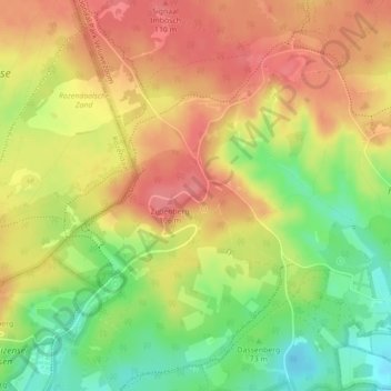
Name: Zijpenberg topographic map, elevation, terrain.
Location: Zijpenberg, Rheden, Gelderland, Nederland, 6991JZ, Nederland (52.02469 6.00237 52.02479 6.00247)
Average elevation: 74 m
Minimum elevation: 30 m
Maximum elevation: 106 m
Other topographic maps
Click on a map to view its topography, its elevation and its terrain.
Nationaal Park Veluwezoom
Nederland > Gelderland > Rheden
Nationaal Park Veluwezoom, Burgemeester Bloemersweg, Rheden, Gelderland, Nederland, 6991JM, Nederland
Average elevation: 50 m
Signaal Imbosch
Nederland > Gelderland > Rheden
Signaal Imbosch, Rheden, Gelderland, Nederland, 6991 JZ, Nederland
Average elevation: 86 m
Rozendaalse Beek
Nederland > Gelderland > Rheden
Rozendaalse Beek, Rheden, Gelderland, Nederland, 6881LE, Nederland
Average elevation: 33 m