
Cárdenas topographic map
Interactive map
Click on the map to display elevation.
About this map
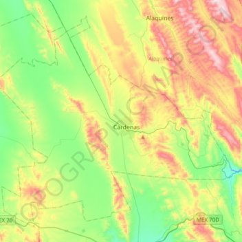
Name: Cárdenas topographic map, elevation, terrain.
Location: Cárdenas, San Luis Potosí, México (21.88431 -99.80942 22.13079 -99.50455)
Average elevation: 1,250 m
Minimum elevation: 951 m
Maximum elevation: 1,754 m
Other topographic maps
Click on a map to view its topography, its elevation and its terrain.
Soledad de Graciano Sánchez
Soledad de Graciano Sánchez, San Luis Potosí, México
Average elevation: 1,900 m
Ciudad Valles
México > San Luis Potosí > Ciudad Valles
Ciudad Valles, San Luis Potosí, 79000, México
Average elevation: 181 m