
Draché topographic map
Interactive map
Click on the map to display elevation.
About this map
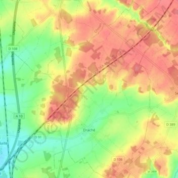
Name: Draché topographic map, elevation, terrain.
Average elevation: 85 m
Minimum elevation: 46 m
Maximum elevation: 118 m
La Manse, d'une longueur totale de 30,5 km, prend sa source à une altitude de 117 m sur la commune de Bossée et se jette dans la Vienne à L'Île-Bouchard, à 32 m d'altitude, après avoir traversé 11 communes. Sur le plan piscicole, la Manse est classée en deuxième catégorie piscicole. Le groupe biologique dominant est constitué essentiellement de poissons blancs (cyprinidés) et de carnassiers (brochet, sandre et perche).
Other topographic maps
Click on a map to view its topography, its elevation and its terrain.
Cheillé
France > Centre-Val de Loire > Indre-et-Loire
Cheillé, Tours, Indre-et-Loire, Centre-Val de Loire, France métropolitaine, 37190, France
Average elevation: 91 m
Descartes
France > Centre-Val de Loire > Indre-et-Loire
Descartes, Loches, Indre-et-Loire, Centre-Val de Loire, France métropolitaine, 37160, France
Average elevation: 90 m
Le Liège
France > Centre-Val de Loire > Indre-et-Loire
Le Liège, Loches, Indre-et-Loire, Centre-Val de Loire, France métropolitaine, 37460, France
Average elevation: 119 m
Tours
France > Centre-Val de Loire > Indre-et-Loire
Tours, Indre-et-Loire, Centre-Val de Loire, France métropolitaine, France
Average elevation: 73 m
Luzillé
France > Centre-Val de Loire > Indre-et-Loire
Luzillé, Loches, Indre-et-Loire, Centre-Val de Loire, France métropolitaine, 37150, France
Average elevation: 106 m
La Ville
France > Centre-Val de Loire > Indre-et-Loire > Sainte-Maure-de-Touraine
La Ville, Sainte-Maure-de-Touraine, Chinon, Indre-et-Loire, Centre-Val de Loire, France métropolitaine, 37800, France
Average elevation: 97 m
Château
France > Centre-Val de Loire > Indre-et-Loire > Sainte-Maure-de-Touraine > La Ville
Château, Rue du Château, La Ville, Sainte-Maure-de-Touraine, Chinon, Indre-et-Loire, Centre-Val de Loire, France métropolitaine, 37800, France
Average elevation: 92 m
Les Évées
France > Centre-Val de Loire > Indre-et-Loire > Saint-Martin-le-Beau
Les Évées, Saint-Martin-le-Beau, Loches, Indre-et-Loire, Centre-Val de Loire, France métropolitaine, 37270, France
Average elevation: 71 m
Courçay
France > Centre-Val de Loire > Indre-et-Loire
Courçay, Loches, Indre-et-Loire, Centre-Val de Loire, France métropolitaine, 37310, France
Average elevation: 87 m
Monts
France > Centre-Val de Loire > Indre-et-Loire
Monts, Tours, Indre-et-Loire, Centre-Val de Loire, France métropolitaine, 37260, France
Average elevation: 81 m
Saint-Pierre-des-Corps
France > Centre-Val de Loire > Indre-et-Loire
Saint-Pierre-des-Corps, Arrondissement de Tours, Indre-et-Loire, Centre-Val de Loire, France métropolitaine, 37700, France
Average elevation: 55 m
Tours
France > Centre-Val de Loire > Indre-et-Loire > Tours
Tours, Indre-et-Loire, Centre-Val de Loire, France métropolitaine, 37000, France
Average elevation: 91 m
Marolle
France > Centre-Val de Loire > Indre-et-Loire > Genillé
Marolle, Genillé, Loches, Indre-et-Loire, Centre-Val de Loire, France métropolitaine, 37460, France
Average elevation: 122 m
Les Quarts
France > Centre-Val de Loire > Indre-et-Loire > Montbazon
Les Quarts, Montbazon, Arrondissement de Tours, Indre-et-Loire, Centre-Val de Loire, France métropolitaine, 37250, France
Average elevation: 78 m
Yzeures-sur-Creuse
France > Centre-Val de Loire > Indre-et-Loire
Yzeures-sur-Creuse, Loches, Indre-et-Loire, Centre-Val de Loire, France métropolitaine, 37290, France
Average elevation: 95 m
Tour Heurtault
France > Centre-Val de Loire > Indre-et-Loire > Amboise > La Ville-Sud
Tour Heurtault, Place Michel Debré, Quai du Maréchal Joffre, La Ville-Sud, Amboise, Loches, Indre-et-Loire, Centre-Val de Loire, France métropolitaine, 37400, France
Average elevation: 71 m
Cinais
France > Centre-Val de Loire > Indre-et-Loire > Cinais
Cinais, Chinon, Indre-et-Loire, Centre-Val de Loire, France métropolitaine, 37500, France
Average elevation: 49 m
Loches
France > Centre-Val de Loire > Indre-et-Loire
Loches, Indre-et-Loire, Centre-Val de Loire, France métropolitaine, 37600, France
Average elevation: 106 m
Richelieu
France > Centre-Val de Loire > Indre-et-Loire
Richelieu, Chinon, Indre-et-Loire, Centre-Val de Loire, France métropolitaine, 37120, France
Average elevation: 62 m
Langeais
France > Centre-Val de Loire > Indre-et-Loire > Langeais
Langeais, Chinon, Indre-et-Loire, Centre-Val de Loire, France métropolitaine, 37130, France
Average elevation: 82 m
Villaines-les-Rochers
France > Centre-Val de Loire > Indre-et-Loire
Villaines-les-Rochers, Arrondissement de Tours, Indre-et-Loire, Centre-Val de Loire, France métropolitaine, 37190, France
Average elevation: 97 m