
Centre Ville topographic map
Interactive map
Click on the map to display elevation.
About this map
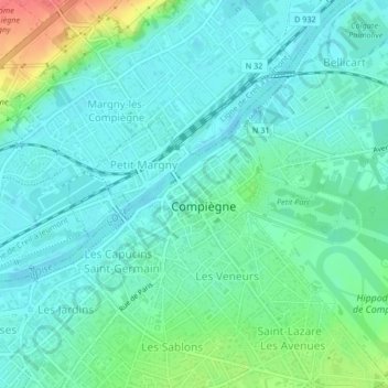
Name: Centre Ville topographic map, elevation, terrain.
Average elevation: 45 m
Minimum elevation: 29 m
Maximum elevation: 93 m
Other topographic maps
Click on a map to view its topography, its elevation and its terrain.
La Victoire - Les Maréchaux
France > Hauts-de-France > Compiègne
La Victoire - Les Maréchaux, Compiègne, Oise, Hauts-de-France, France métropolitaine, 60200, France
Average elevation: 46 m
Camp de Royallieu
France > Hauts-de-France > Compiègne
Camp de Royallieu, Compiègne, Oise, Hauts-de-France, France métropolitaine, 60200, France
Average elevation: 42 m