
Trois-Rivières topographic map
Interactive map
Click on the map to display elevation.
About this map
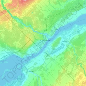
Name: Trois-Rivières topographic map, elevation, terrain.
Location: Trois-Rivières, Mauricie, Québec, G9A 2H1, Canada (46.18323 -72.70285 46.50323 -72.38285)
Average elevation: 38 m
Minimum elevation: 1 m
Maximum elevation: 191 m
Other topographic maps
Click on a map to view its topography, its elevation and its terrain.
Rivière Saint-Maurice
Canada > Québec > Trois-Rivières > Trois-Rivières
Rivière Saint-Maurice, Trois-Rivières, Mauricie, Québec, Canada
Average elevation: 394 m
Parc des Prairies
Canada > Québec > Trois-Rivières > Trois-Rivières
Parc des Prairies, Trois-Rivières, Mauricie, Québec, Canada
Average elevation: 43 m