
土们岭街道 topographic map
Interactive map
Click on the map to display elevation.
About this map
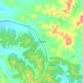
Name: 土们岭街道 topographic map, elevation, terrain.
Location: 土们岭街道, 长春市, 吉林省, 130000, 中国 (44.06078 126.00625 44.14078 126.08625)
Average elevation: 305 m
Minimum elevation: 220 m
Maximum elevation: 517 m
Other topographic maps
Click on a map to view its topography, its elevation and its terrain.
南岭1932 长春水文化生态园
南岭1932 长春水文化生态园, 鸿城街道, 南关区, 长春市, 吉林省, 130000, 中国
Average elevation: 216 m