
Gave de Sainte-Engrâce / Uhaytza topographic map
Interactive map
Click on the map to display elevation.
About this map
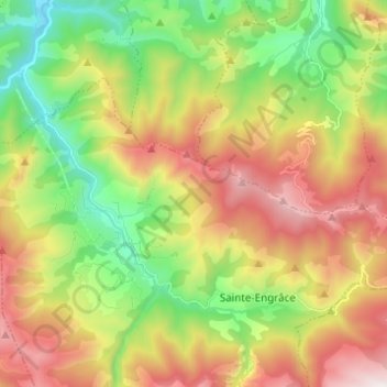
Name: Gave de Sainte-Engrâce / Uhaytza topographic map, elevation, terrain.
Average elevation: 882 m
Minimum elevation: 268 m
Maximum elevation: 1,681 m
Other topographic maps
Click on a map to view its topography, its elevation and its terrain.
La Caserne
France > Nouvelle-Aquitaine > Pyrénées-Atlantiques > Sainte-Engrâce
La Caserne, Sainte-Engrâce, Oloron-Sainte-Marie, Pyrénées-Atlantiques, Nouvelle-Aquitaine, France métropolitaine, 64560, France
Average elevation: 742 m
Calla
France > Nouvelle-Aquitaine > Pyrénées-Atlantiques > Sainte-Engrâce
Calla, Sainte-Engrâce, Oloron-Sainte-Marie, Pyrénées-Atlantiques, Nouvelle-Aquitaine, France métropolitaine, 64560, France
Average elevation: 886 m