
Ehlanzeni topographic map
Interactive map
Click on the map to display elevation.
About this map
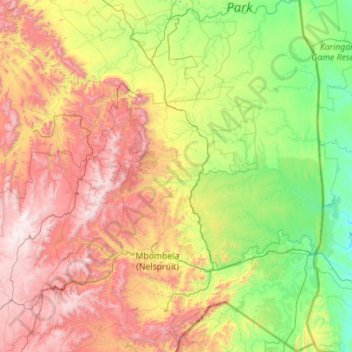
Name: Ehlanzeni topographic map, elevation, terrain.
Location: Ehlanzeni, Mpumalanga, RSA (-25.99960 29.97895 -23.98124 32.03372)
Average elevation: 763 m
Minimum elevation: 72 m
Maximum elevation: 2,312 m
Other topographic maps
Click on a map to view its topography, its elevation and its terrain.
Mbombela (Nelspruit)
RSA > Mpumalanga > Mbombela (Nelspruit)
Mbombela (Nelspruit), Ehlanzeni, Mpumalanga, 1212, RSA
Average elevation: 833 m