
Thank you for supporting this site ❤️
Make a donation
Make a donation
Tamsui District topographic map
Click on the map to display elevation.
Thank you for supporting this site ❤️
Make a donation
Make a donation
About this map
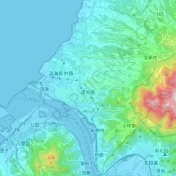
Name: Tamsui District topographic map, elevation, terrain.
Location: Tamsui District, New Taipei, Taiwan (25.12291 121.39573 25.24440 121.52258)
Average elevation: 120 m
Minimum elevation: -3 m
Maximum elevation: 1,014 m
Thank you for supporting this site ❤️
Make a donation
Make a donation
Other topographic maps
Click on a map to view its topography, its elevation and its terrain.