
Johnson County topographic map
Interactive map
Click on the map to display elevation.
About this map
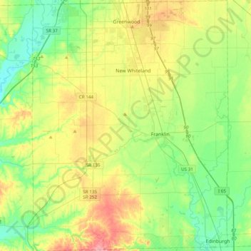
Name: Johnson County topographic map, elevation, terrain.
Location: Johnson County, Indiana, United States (39.34202 -86.25141 39.63850 -85.95087)
Average elevation: 232 m
Minimum elevation: 189 m
Maximum elevation: 310 m
Other topographic maps
Click on a map to view its topography, its elevation and its terrain.
Banta
United States > Indiana > Johnson County > Bargersville
Banta, Bargersville, Johnson County, Indiana, United States
Average elevation: 232 m
Greenwood
United States > Indiana > Johnson County
Greenwood, Johnson County, Indiana, United States
Average elevation: 245 m