
Make a donation
Boston topographic map
Click on the map to display elevation.
Make a donation
About this map
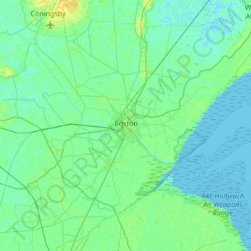
Name: Boston topographic map, elevation, terrain.
Average elevation: 3 m
Minimum elevation: -2 m
Maximum elevation: 14 m
Make a donation
Other topographic maps
Click on a map to view its topography, its elevation and its terrain.
Shepeau Stow
United Kingdom > England > Lincolnshire > South Holland > Whaplode Drove
Average elevation: 2 m
Make a donation
Make a donation
The Lymn
United Kingdom > England > Lincolnshire > East Lindsey > Thorpe St. Peter
Average elevation: 2 m
Make a donation
Make a donation
Make a donation
Make a donation
Make a donation
Scottlethorpe
United Kingdom > England > Lincolnshire > South Kesteven > Edenham
Average elevation: 49 m
Caen Hill
United Kingdom > England > Lincolnshire > West Lindsey > Great Limber CP
Average elevation: 83 m
Make a donation
Holbeach Clough
United Kingdom > England > Lincolnshire > South Holland > Holbeach CP > Saracen's Head
Average elevation: 4 m
Make a donation
Moor Barn
United Kingdom > England > Lincolnshire > South Kesteven > Hough-on-the-Hill
Average elevation: 31 m
Make a donation
Make a donation
Make a donation
Acre Bridge
United Kingdom > England > Lincolnshire > East Lindsey > Conisholme
Average elevation: 2 m
Make a donation
Skellingthorpe Moor Plantation
United Kingdom > England > Lincolnshire > Lincoln
Average elevation: 17 m
Make a donation
Make a donation
Make a donation
Make a donation
Make a donation
Woolsthorpe-by-Belvoir
United Kingdom > England > Lincolnshire > South Kesteven
Average elevation: 82 m
Make a donation
Make a donation
Low Fulney Estate
United Kingdom > England > Lincolnshire > South Holland > Spalding
Average elevation: 4 m
Make a donation
Sempringham
United Kingdom > England > Lincolnshire > South Kesteven > Pointon
Sempringham consists of a church and a holy well, with other houses east from the church scattered along the B1177 between Pointon and Billingborough. The church stands at an altitude of about 52 feet (16 m), on land rising out of flat fenland. Pointon is the chief township of the civil parish, which includes…
Average elevation: 16 m
Make a donation
Quarrington
United Kingdom > England > Lincolnshire > North Kesteven
According to the Köppen classification, the British Isles experience a maritime climate characterised by relatively cool summers and mild winters. Lincolnshire's position on the east of the Isles allows for a sunnier and warmer climate relative to the national average, and it is one of the driest counties in…
Average elevation: 21 m
Wainfleet Haven
United Kingdom > England > Lincolnshire > East Lindsey > Wainfleet Clough
Average elevation: 3 m
Make a donation
Spalding Marsh
United Kingdom > England > Lincolnshire > South Holland > Weston CP
Average elevation: 4 m
Make a donation
Rase Park
United Kingdom > England > Lincolnshire > West Lindsey > Market Rasen
Average elevation: 28 m
Make a donation